Introduction
The SALDi Project is a South-African funded research project aimed at developing new tools for assessing land degradation
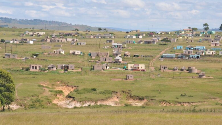
Land degradation leads to a decline in vegetation, soil degradation and damage to other ecosystem functions.
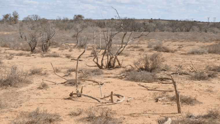
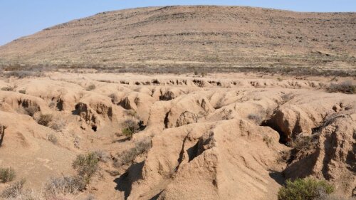
Gully Erosion in Eastern Cape, South Africa
Image: J. Baade 2010Against the background of widespread land degradation in South Africa, SALDi pursues the following overarching objectives:
1) Development of a permanent observation system (monitors) for ecosystem changes and degradation by satellite remote sensing.
2) Modelling of the interactions of surface changes, weather and climate.
3) Improvement of methods for the evaluation of soil degradation, especially soil erosion by water.
4) Consideration of socio-economic dimensions and impacts of land degradation and evaluation of SALDi products by local actors.
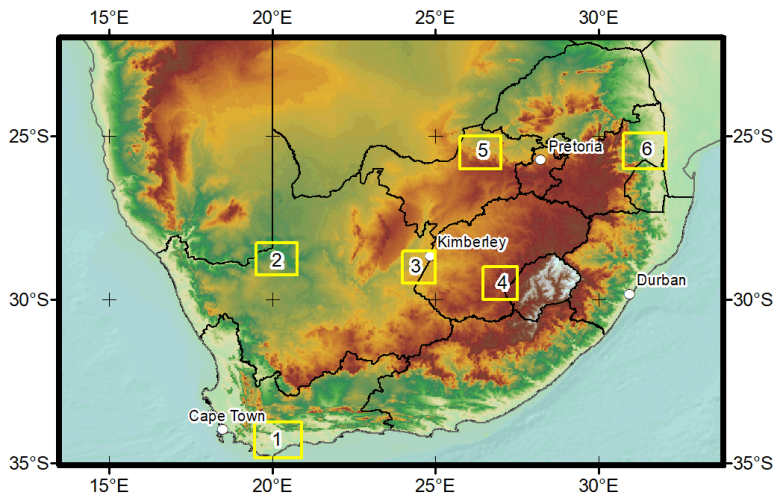
Fig. 1: SALDi study areas and topographic map of South Africa
Picture: J. Baade 2020/ FSU Jena (data: ESRI 2013, NOAA 2006)Figure 1 shows the location of the six study areas on a topographic map of South Africa Two areas are located in the coastal lowlands, while the other four areas are located on the central high plateau. The entire southern Africa region shown on the map marks the area for hydroclimate modeling in the sub-project TP2 conducted by our partner's at the University of Augsburg.
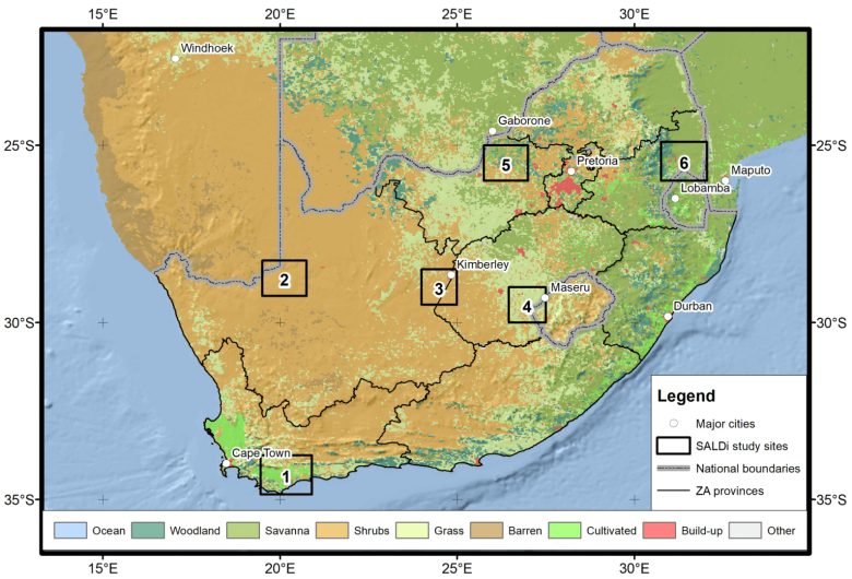
Fig. 2: SALDi study areas and simplified land cover map of South Africa (1: Overberg, Western Cape, 2: Kai !Garib, Northern Cape, 3: Sol Plaatje, Northern Cape, 4: Mantsopa, Free State, 5: Bojanala Platinum, North West, 6: Ehlanzeni, Mpumalanga
Picture: J. Baade 2021/ FSU Jena (Datengrundlage: eigene Aufnahmen, ESRI 2013, vereinfachte MODIS Land Cover cf. FRIEDL et al. 2010)The study sites cover the climatic gradient from the semi-arid winter-rainfall region in the southwest (1: Overberg) across the central semi-arid year-round-rainfall region to the semi-humid summer-rainfall region in the northeast (6: Ehlanzeni). At the same time the study areas reflect other natural differences like land cover (Fig. 2) as well as the sozio-economic and cultural diversity in South Africa.
An analysis of the land cover in the six study areas (Fig. 3) provides evidence of the massive impact of climate conditions on the utilization of land. In the Overberg region in the southwest, about 75 % of the area is cultivated, while woodlands and plantations cover more than 50 % of the area in Ehlanzeni. In Kai !Garib and Sol Plaatje, shrubs represent the dominant land cover, while Mantsopa and Bojanala Platinum are characterized by a more even land cover distribution. It is this diversity of land utilization which supports the aspiration to eventually provide overall results applicable to the whole of South Africa and beyond.
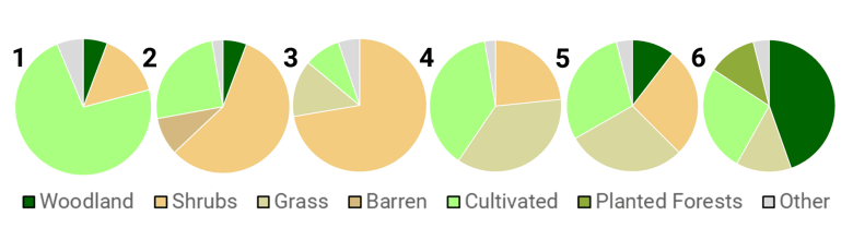
Fig. 3: Land cover characteristics in the six SALDi study areas (1: Overberg, 2: Kai !Garib, 3: Sol Plaatje, 4: Mantsopa, 5: Bojanala Platinum, 6: Ehlanzeni)
Picture: M. Urban & J. Baade 2021/ FSU Jena (Datengrundlage: CD: NGI & LRI 2018)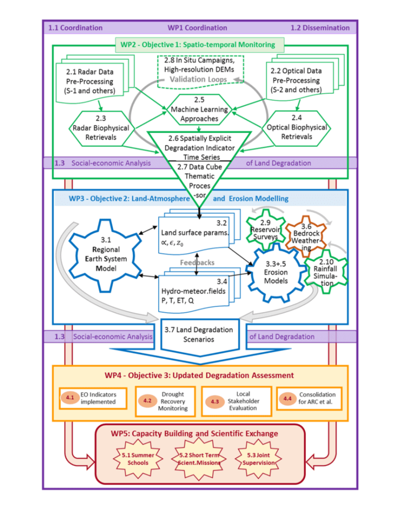
Abb. 4: SALDi flow chart
Picture: C. Schmullius/ FSU JenaThe workflows in SALDi are structured around five (5) Work Packages (WP), namely
WP1: Coordination,
WP2: Spatio-temporal monitoring,
WP3: Modelling of land-atmosphere interactions and soil erosion,
WP4: Synergistic improvement of land degradation assessment
WP5: Capacity building and scientific exchange.
All sub-projects (TP) as well as the South African partners contribute to the different work packages.
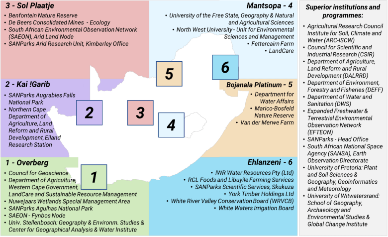
Fig. 5: Network of regional and local stakeholders and cooperation partners in South Africationspartner in Südafrika
Picture: C. Schmullius & M. Urban 2021/ FSU JenaSALDi cooperates closely with institutions and universities in South Africa and has direct connections to relevant South African stakeholder groups at local, regional and national level (Fig. 5). First of all, the tandem partner Agricultural Reasearch Council, Institute for Soil, Climate and Water (ARC-ISCW) should be mentioned. In addition, the National Park Administration's scientific service (SANParks), the South African National Space Agency (SANSA), the Council for Scientific and Industrial Research (CSIR), the utility Eskom and colleagues at the universities in Pretoria, Stellenbosch, Bloemfontein and Potchefstroom. They also provide multipliers for the dissemination of the results in the administrations and ministries (e.g. Department of Agriculture, Land Reform and Rural Development (DALRRD), Department of Environment, Forestry and Fisheries (DEFF) and Department of Water and Sanitation (DWS) with their local branches in South Africa. SASSCAL also supports this. In addition, the network was significantly expanded, particularly with local and regional partners and stakeholders, as part of the field visits. The network now includes the institutions listed in Figure 5 for the six SALDi study sites.